Update 2022
Still by far the most viewed blog on my website.
If you’d like to learn more about the GHQ Line and the Home Forces, then head over to the UK Second World War Heritage website and our new Home Forces Resources.
Update 2021
This has proven to be my most popular post so far!
If you would like to help support my work, why not Buy Me A Coffee over on Ko-Fi?
If you would like to find out more about how to record and help preserve wartime sites and structures, please do join the UK Second World War Heritage Facebook group and check out the website, where you can find a range of resources and information UKSWWH Website.
I wrote this blog back in 2015 and the research has developed over the years. As a result, this blog only represents my initial research and plotting of the GHQ line that was constructed and in operation from June to August 1940. That’s right, the GHQ line and stop-line strategy employed by General Ironside was only in use officially for 2 months! Ironside’s replacement, General Alan Brooke, implemented a strategy of nodal points, anti-tank islands and centres of resistance lasted from July 1940 until the anti-invasion defences were stood down around December 1942/early 1943, which was much longer than the stop line strategy lasted. But that is all but forgotten today and most people have a very poor understanding of the actual history of these defences, other than what they read online from sites and individuals that just regurgitate mythology and folklore.
Although these almost temporary stop-lines seem to grab the attention of many, a lot more research is required to gain a true understanding of wartime anti-invasion defences and how they developed over their relatively short life-span. We still know very little about these defences, their history or their development, apart from a broad overview of what was happening at a national level. As they were never used, we still have a very poor idea of how successful they would have been. This is further exacerbated by the fact the pillboxes that survive today represent only a fraction of the defences originally constructed. That and very few people consider the number of troops from the Regular and Territorial forces that were stationed on the coast and inland to act as a mobile force to counter attack and hold the invading force had it come.
We also see that the vitally important role of the regular and territorial armies within the network of anti-invasion defences has been all but forgotten and almost written out of the standard narrative of the period; often in favour of an almost fairy-tale story of old men and young boys taking up arms to defend their homes and the country. It’s a shame that the current historical narrative and understanding of this time in public consciousness has almost completely been shaped by the 70s sitcom Dad’s Army. As a result, the Home Guard are now seen as the primary force behind the anti-invasion defences, when in reality they weren’t. The Home Guard were just one component of the anti-invasion defences and were not responsible for front line defence during the height of the invasion threat of summer 1940. Their role differed extensively across the country but, unfortunately, due to a lack of research at a local level their true role is somewhat overstated. In essence their primary role was to sit behind the regular and territorial army, protect their locality if needs be, support the regulars where necessary and operate within their operational orders. It wasn’t until much later in the Second World War, in a lot of cases not until 1943, that the Home Guard started to take on the primary defence of coastal areas. At this point, the imminent threat of invasion had been over for almost a year and the anti-invasion defences, many of which had already been dismantled, were being reduced to further free up the regular army for front line service elsewhere.
It is now more important than ever that the true story of this period of the Second World War is researched and written as the current narrative is largely shrouded in myth.
IMPORTANT BIT!
While I’ve got your attention, if you would like to learn how to research and record Second World War defences in the UK please also check out my Recording Guide. This is my first attempt at writing a standardised method for recording wartime defences. This is very important as Second World War defences are rarely thoroughly investigated or recorded in any detail.
There are currently serious problems in terms of the conservation of wartime sites. This is mainly due to local Historic Environment Records (HER) not receiving the detailed information required to aid their work in informing the planning process. As the HERs act as the primary source of information for planning applications, land management and development work, adding relevant information to these local services is very important. Although interest in wartime defences is increasing rapidly, there is little guidance online to how to record sites to archaeological standards, and as a result recording methodology has regressed significantly.
Currently, there is a lack of information regarding how people can record sites and make a difference. For over 15 years amateur groups have promoted the ‘spotting’ of defences. This usually involves taking a photo, posting it to social media and nothing else. This has led to a lack of information reaching HERs, and has also led many to believe posting photographs to social media platforms is all that is required to preserve wartime sites. Due to these current issues, we are now seeing that many defences remain extremely vulnerable due to this lack of guidance and the animosity some groups currently promote against professional heritage organisations. I have recently witnessed ‘HER and Historic England bashing’ by representatives of groups who should know a lot better and have had little actual engagement with HERs.
The Defence of Britain Project and Defence Areas projects set the foundation for the archaeological recording and archive research of Second World War defences. As these projects came to an end in 2002 and 2005, a return to the methodology devised and promoted by them is long overdue. Yes, the Defence of Britain is no longer active and ended 20 years ago. Online maps, especially EDoB, are in no way connected to the original Defence of Britain project, are not an official continuation of the Defence of Britain Project, and are by no means endorsed by the Council for British Archaeology or Archaeological Data Service. EDoB also does not represent current methodology for the recording of wartime defences. As a result, online maps like EDoB are not recognised or endorsed by any professional heritage organisation or local Historic Environment Record and have no responsibility, official or otherwise, for the preservation of wartime sites and defences in the UK. ‘Recording’ sites with EDoB in no way ensures their preservation and in most cases sees important information withheld from the very organisations that are responsible for preserving sites of archaeological and historic interest in the UK. This sits alongside other serious issues EDoB has in regards to plagiarism, infringement of landowner privacy, drawing attention to vulnerable sites and structures, as well as almost industrial scale copyright infringement of archaeological records, published works, and academic reports/papers.
I recommend direct contact with your local Historic Environment Record, instead of relying on online pillbox spotting map projects to do recording on your behalf. It is clearly stated on the ADS archive of the Defence of Britain project that local Historic Environment Records should be the first point of contact for any corrections to the data. It’s a good idea to always check with your local Historic Environment Record that they are aware of any projects you find online and that they are receiving data from them.
If you really want to help make a difference and help preserve sites, contact you local Historic Environment Record and see what information they require to update their records relating to Second World War sites and structures.
You can find out more about the role of the Historic Environment Record and how to contact them over on the UK Second World War Heritage website. Additional information can be found in the UKSWWH Historic Environment Records: An Introduction guide
Unfortunately, we are still a long way off fully understanding the defences that survive today. However, with some basic research techniques and simple recording methods anyone can help to add further significance to their local wartime heritage assets.
Finally, I haven’t published the GHQ line map online and have no plans to do so.
Back to the blog!
Well, it’s been a while since I’ve posted a blog, this one has been in the planning stage for a while now following a prolonged period of ‘writer’s block’ and a very uncooperative brain. Without further ado here it is.
Earlier this year I was forwarded a question via a colleague. The question I was posed related to the GHQ stop-line; the defence line planned by General Edmund ‘Tiny’ Ironside in June 1940, following his appointment as Commander-in-Chief of the Home Forces on the 17th of May 1940.
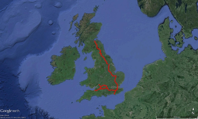
The GHQ line (or General Head Quarters stop-line) was to be the final line of defence running East from Bristol to the Thames Estuary then North to Edinburgh. This line was intended to protect the industrial heartland of the country had an invading German Army managed to breach the Coastal Crust defences, inland nodal points and secondary stop-lines. This defence line consisted of Infantry and Anti-tank pill-boxes, roadblocks, barbed wire entanglements, anti-tank obstacles and trench systems.
There’s some background for you, now back to the question.
As the question related to the length of the GHQ line and the route which it followed I decided to ascertain the length of the GHQ line had it been completed and the length of the GHQ line that was actually constructed between June and August 1940. Construction of the GHQ line having been slowed and eventually halted following the appointment of General Alan Brooke as Commander-in-Chief of the Home Forces on the 21st of July 1940. Ironside was subsequently retired and the defence strategy altered significantly, but that’s another story.
Initially I thought this was quite a straightforward question and I’d find the answer in one of the many books on the subject. I was wrong; although I could find plenty of information regarding the intended route of the GHQ line (although there were some distinct differences between sources and all maps were large scale), I could not find any information about the intended length of the line had it been completed.
I did however find a reference to the length of the GHQ line in Mike Osborne’s book ‘Defending Britain’ which states that the section of GHQ line running from the Bristol Channel to the River Welland was approximately 400 miles in length. However, this only takes into account a short stretch of the proposed GHQ line and doesn’t include the GHQ East line that would have run from the River Welland up to Edinburgh. The book does describe the route of the GHQ line in some detail and this information came in handy.
So, although I knew the general route of the GHQ line, I still had a job on to tie down the exact route, trace it, and determine the length of the constructed and proposed GHQ lines.
I decided to work logically, finding and pinpointing the exact route of the GHQ line, I would then plot the information into my favourite tool, Google Earth, to show the route visually and to measure its length as accurately as possible given time constraints.
I consulted my copy Henry Will’s book ‘Pillboxes’, this has not one but many maps showing the GHQ line, including a copy of Ironside’s original map of divisional dispositions which shows the GHQ line, and 1:625 000 scale Ordnance Survey maps showing various lines of pill-boxes.
Comparing the maps in Will’s book with further examples I could find in other books showed there was a general consensus about the route of the GHQ line, with some slight variations, which allowed me to narrow down the area through which it ran. There was a slight problem though as most of the maps were large scale, making it hard to pinpoint the exact route in relation to nearby towns and cities.
A quick Google search will provide you with similar maps of the GHQ line (Note the differences).
With this information the next step was to see how it compared to the archaeological record.
The Defence of Britain project was conducted between 1995 and 2002. This project aimed to record the extant 20th century military sites in the UK. The project was a huge success and the results of this project have greatly improved our understanding of the 2nd World War defensive landscape.
The results of the Defence of Britain project have been converted into a Google Earth (Available here via the ADS website) which is very useful as I love Google Earth.
With the Defence of Britain data loaded into Google Earth it is very easy check the locations of the project results, trace stop-lines, and pick out features using modern aerial photography.
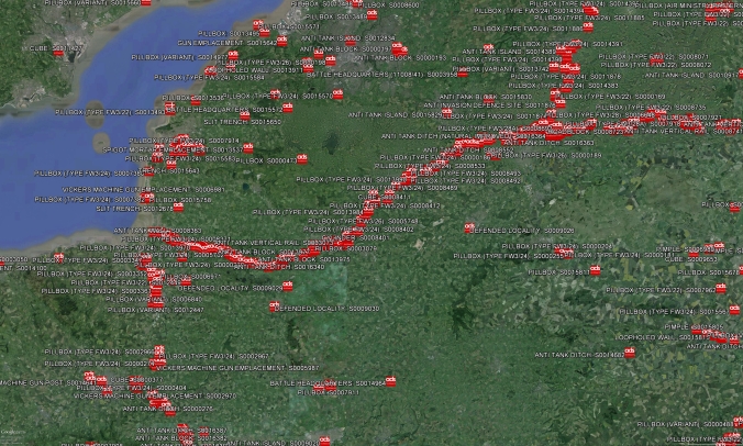
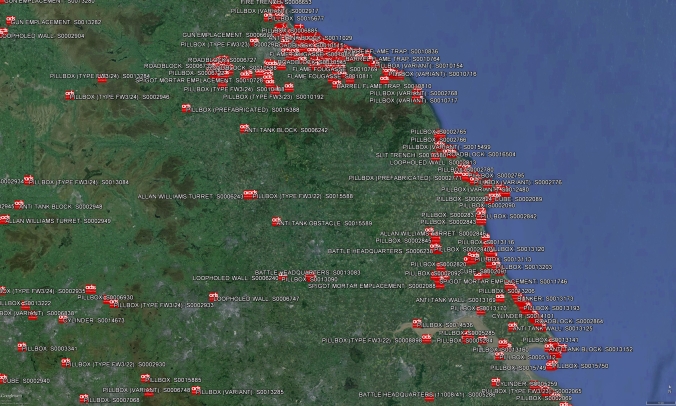
Defence of Britain project overlay in Google Earth with GHQ line visible
Looking at the distribution of pill-boxes in particular, one of the main defence types that formed the GHQ lines, it was possible to quickly discern numerous stop-lines within the UK. It was then simply a matter of using the maps and diagrams I had gathered to discern the GHQ line and follow the trail of records.
Using Google Earth’s ‘Path’ tool I simply followed the route of the various GHQ lines, picking them out in a nice Red colour.
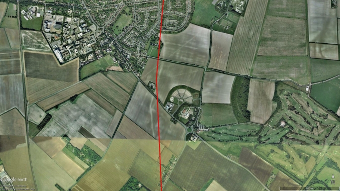
Plotting a path in Google Earth following the River Brue
While plotting the GHQ line I did encounter a number of gaps, probably due to defences being demolished, un-recorded or not constructed at all. It was clear that the GHQ line followed many of the local rivers, canal systems and many natural or man-made obstacles (Such as railway embankments & high-ground) and I was aware that this was a strategy employed in siting the GHQ lines.
Henry Wills (1985) summarises the choice of topography- ‘The GHQ line followed natural and artificial waterways, using topographical features where possible, to create a continuous anti-tank obstacle’.
To fill in these gaps in the line it was just a matter of following the river, rail or canal network the GHQ line would have followed and plotting it that way. In some areas these features were not present, which suggests that either the GHQ line had followed an anti-tank ditch, or other feature that has since been removed, I had to make an educated guess using the large scale maps I had available. We will see later this proved quite effective!
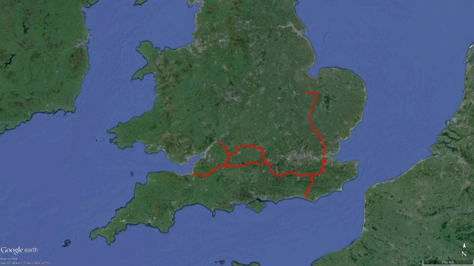
After a very short time I had most of the Southern GHQ line plotted, running parallel to the South Coast, around London and then towards Cambridge. As the line nears Peterborough the line stops abruptly. I’ve come to the conclusion that this marks the progress of the GHQ line up to the appointment of General Brooke, who gradually halted construction of the GHQ line. Quite impressive for what was at most three months work!
Length of GHQ line constructed
The GHQ East line, which would have run from the Thames to the Humber Estuary and through Yorkshire on to Edinburgh, is largely non-existent and as a result hard to trace. The only way to trace this route was to utilise the maps I had found, especially Will’s OS maps, and follow the major rivers and canal networks. It took a while and some detective work but eventually it was possible to map the most likely route of this stretch of GHQ line.
No visible GHQ line in Yorkshire
By applying a number of methods I eventually had the GHQ line mapped in its entirety, had it been finished. It was then a matter of adding up the lengths of the various ‘paths’ in Google Earth, mainly using a calculator as I am terrible at maths. After a few minutes of calculator bashing I was left with two figures, one for the length of the line constructed and one for the length of the completed GHQ line. Success!
The length of the Constructed GHQ line was approximately 466 miles, while the completed GHQ line would have been approximately 836 miles long (This includes the GHQ Green line around Bristol, the GHQ switch-line around Swindon, the Newhaven-Hoo line and a small switch-line near Stanhope that was illustrated on Henry Will’s map).
So long story short, after a lot of work I was able to provide an approximate figure for the length of the GHQ line (both built and proposed) based on the information and tools I had available. I also had an interactive and visual means of displaying the GHQ line, which was a bonus. I sent this information off to the recipient and everyone lived happily ever after.
But that’s not the end of the story…
There have been a number of unforeseen outcomes from this little project.
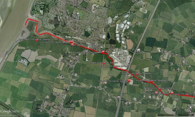
My colleague, who had originally forwarded me the question, sent me a picture of a crop mark they had found while looking at the GHQ overlay. It appeared to be an anti-tank ditch. I found the crop-mark using my GHQ overlay and switching to the 1945 Google Earth aerial photography (Unfortunately not available everywhere) did indeed find an anti-tank ditch. Much of the ditch had been in-filled but it was still plain to see. The Anti-tank ditch had thankfully been recorded through the Defence of Britain project.
GHQ line plotted in red with linear crop-mark to the left
Now here’s the good part: The ‘path’ I had placed in this area passed directly over the anti-tank ditch! As it would have been extremely time consuming to map the GHQ line meter by meter, in some areas I had had to trace the route from afar, using my better judgement and the concentrations of records in the Defence of Britain overlay as a guide. Quite by chance I had accurately followed a single anti-tank ditch that now survived only as a crop-mark. I was well chuffed with this result!
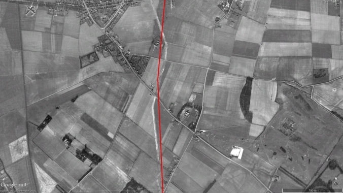
1945 Aerial Photograph showing the extant Anti-Tank ditch
Closer inspection revealed the GHQ line’s reliance on natural and man-made obstacles was abundantly clear now. This highlights the importance of looking at the wider landscape when interpreting defences from this period as opposed to looking at the defensive remains in isolation.
Okay, so ‘where next?’ I hear you ask. Well my next step is to do some further research to check the accuracy of the GHQ line that I have plotted. While writing this blog post it has become clear that a stretch of the line in Cambridgeshire that I have plotted might be inaccurate. This is due to a number of converging stop-lines in this area which makes it difficult to discern the actual GHQ line. This should only take a matter of time but does highlight the issue of conflicting data.
I have continued mapping the Second World War defences in Google Earth, including the extant and proposed Coastal Crust defences and recently I’ve started mapping Secondary Stop Lines. So, watch this space!
The End
Thanks for reading what was one of my first blogs.
If you are serious about making a difference and helping us to better understand surviving wartime sites, then please do join the UK Second World War Heritage Facebook group. UKSWWH resources and guidance can also be found on the UKSWWH Website.
If you’ve got this far and are wondering about accessing a map of the GHQ Line, then have no fear. You can find one integrated into the UK Second World War Heritage Home Forces Resources maps which outlines the distribution of the forgotten Regular and Territorial Army units who were responsible for Home Defence from 1940 onwards.
Bibliography-
Henry Wills (1985) Pillboxes: a study of UK defences, 1940, [London]: Leo Cooper in association with Secker and Warburg
Mike Osborne (2004) Defending Britain: Twentieth-Century military structures in the landscape, [Stroud] Tempus Publishing Ltd

Mapping GHQ lines in Google Earth by Chris Kolonko is licensed under a Creative Commons Attribution-NonCommercial-NoDerivatives 4.0 International License

I might missing something something very simple here but where can I find the Google map? I am going to be up in Bury St Edmonds in a few weeks and want to cycle some of the route.
LikeLike
Hi Paul, I haven’t published the map on-line as it is still a work in progress and will also form part of a future book I intend to write. Kind regards, Chris
LikeLike
Pingback: What do you know about the GHQ Line and military defences? | Lightwater
Chris,
I’ve just found your site as a result of researching the GHQ line. It run right through the village where I live and I found out today that the anti-tank ditch also ran though the garden of an elderly lady I met today. As part of the commemorations denoting 100 years since the end of the 1WW, I am belong to a working party which is creating an exhibition of what my village (Elstead in Surrey) did in both wars.
If I needed to, could I use any of your maps to put on to a poster? I’ve taken photos of all the pill-boxes I know of in the village, but I want to link it to the wider picture, as part of southern defences.
Could you let me know?
With thanks,
Kim Spicer
LikeLike
hi. walked passed what i think is the first pillbox of the stop line next to the river brue. highbridge.somerset. in the adjoining field there looks like an outline of a large building. hard to see from arial photos but clearly visable on foot. any ideas ?barracks ? command center ? how would i go about finding out ?.
cheers.
jay
LikeLike
Hi Jay,
Thank you for getting in touch.
I’ve just checked the Google Earth aerial photographs and can see the large concrete structure you have mentioned. Having checked the Ordnance Survey maps of the area, via http://www.magic.gov.uk, it appears that the structure is a pumping station.
I have however checked Historic Environment Records for the area through the Somerset Historic Environment Record website, just to be sure- https://www.somersetheritage.org.uk/
The search has highlighted a number of records for a Second World War or later radio station that was in the area and not too far from the pumping station- https://www.somersetheritage.org.uk/record/27991 & https://www.somersetheritage.org.uk/record/17888
There’s some other interesting wartime features in the area which can be found via the HER website. If you do spot a wartime structure or feature that isn’t recorded then be sure to let the local HER know of its whereabouts. This will ensure the structure is properly considered during planning applications and may also ensure the long term preservation of the site.
All the best,
Chris
LikeLike
Pingback: Mossy pillboxes | Sussex Bryophytes
Pingback: Wilcot and Huish with Oare
Pingback: Trail talk: The Medway Valley Walk- day one – Three Points of the Compass
I touched on this fascinating piece of British history through a connected project I am presently on with which I hope may help you. My contact was with the Royal Engineers Railway division and transferred to the G,H,Q Home from 1941-45. We have all his service record except for this 1939-45 gap. He kept most of his time with H.G.H.Q to himself and no establishment can provide his record. what I am getting at is M.O.D maps of the stop line and records of its many service personnel are still, I believe secret. I assume there must be a release date in the near future where they will be finally made public. Any recorded experiences of these G.H.Q chaps may offer Stop Line inrormation.
LikeLike
All records relating to the War Department, Home Forces and GHQ line during the Second World War are archived within the National Archives in Kew and have been open since the late 70s to mid-1980s. The MOD don’t retain any files relating to these defences. This is the reason many people who contact the MOD for information come back empty handed, rather than the records being secret.
Home Forces information is held within file WO 199- https://discovery.nationalarchives.gov.uk/browse/r/h/C14406
And information regarding individual service records can be found on the National Archives website here- https://www.nationalarchives.gov.uk/help-with-your-research/research-guides/second-world-war/
LikeLike